|
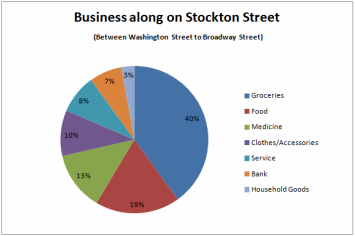
Shoppers on Stockton Street have a wide selection of businesses to choose from; Stockton Street is a one stop street for everything. Stores on Stockton Street sells various items from groceries to household good and have provide services from banking to travel agencies. Stockton Street is one of the largest streets where grocery store and food stores dominate. As there are many competing grocery stores that sell the same products, competition for the most business and who can sell a product for its cheapest price is a challenge for most stores. Some grocery stores sell groceries at wholesale prices to gain the most profit. The amount of large grocery stores located on Stockton Street allows the shopper to get the best price for its products but it’s a constant challenge for grocery store business owners.
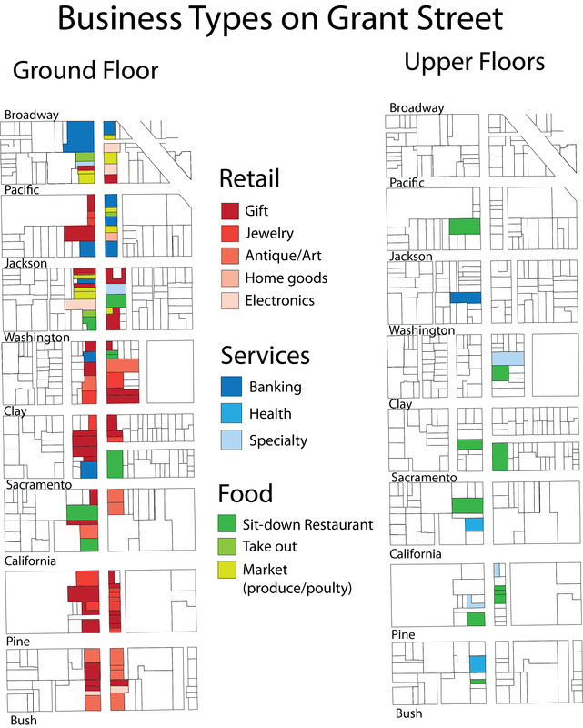
Due to the cheap prices for groceries, it attracts residents from all over Bay Area. Although Stockton Street is extremely overcrowded, it does not deter customers from traveling from other districts and cities to purchase its goods. Not only does the cheap prices attract their customers, but also the comfort of a Chinese speaking environment and Chinese goods that are not present in American groceries stores such as Albertsons. Another reason why businesses are doing very well on Stockton street is due to its nearby proximity to bus stops, especially the 30, 8x, and 45. The majority of buildings on Stockton street are small businesses. On Stockton street, the majority of the buildings are zoned under the classification "CRNC", which represents buildings that are residential and neighborhood commercial. Chinatown is the second most densely populated area in America and because of this, all space within Chinatown is very valuable to the Chinatown community. Most of the buildings in Chinatown are only allowed to be four stories tall because of the zoning law enacted in Chinatown to prevent gentrification. The zoning law enacted in Chinatown allows small family businesses to grow and at the same time prevents large chain corporations to move into the area. Businesses within Chinatown do not have a great need for English speaking employees which attracts Chinese speaking workers from all around the Bay Area. Through an informal interview with an employee from Gourmet Delight BBQ, a reason why he continues to work in a Chinese food deli is because he cannot find work elsewhere due to his inability to speak English. He travels every day by public transportation from the Sunset District to Chinatown. He says that he would like a change in employment but the language barrier disables him from finding work elsewhere. We classified the types of businesses on Grant street into three main categories: retail, services, and food. Retail shops were broken down into gift shops, jewelry stores, antique/art, home goods, and electronics. We observed that foot traffic on Grant beginning at Bush Street catered to mostly tourists. Around the Jackson intersection, shops begin to include more businesses that serve residents. To get more information, we interviewed 17 stores throughout Grant Ave including antique, electronic, tea, souvenirs, and service shops. Almost all of the employees of these retail stores do not live in Chinatown, but they do live in San Francisco. It makes sense in that recent immigrants may not speak enough English to work on the “Tourist Street.” However, in the food service industry in Chinatown, workers are local because they communicate in Chinese when preparing food in restaurants. We can conclude that Chinatown does not provide enough jobs for its residents, and this means that they travel to other parts of the city to work. Successes Grant Ave. is an inviting and convenient site for tourists and residents alike. A lot of the businesses, particularly boutique and souvenir shops, enjoy the constant flow of customers to their stores. This distinct corridor has only small businesses, due to the community’s demand preventing chain stores from competing with local businesses. Grant Ave. is also where many major festivals are hosted, such as Autumn Moon Festival and Noodle Fest, which brings people from all over San Francisco to Chinatown. Another big event is Sunday Streets that is coming to Chinatown’s Grant Ave. this August 26th. it is an rotating event in San Francisco where streets in a neighborhood are closed off for public open space to promote strong communities. Sunday Streets will be beneficial to the Chinatown community not only because it’ll keep people coming back to Chinatown, but it’ll also promote the businesses in the neighborhood from the increased pedestrian traffic. Challenges
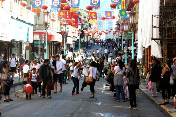
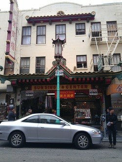
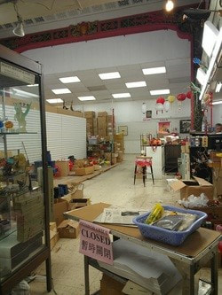
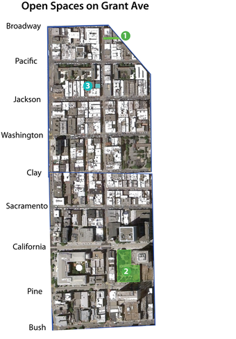
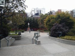
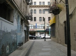
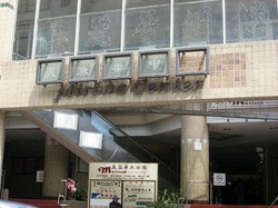
Most of the storefronts along Grant have been open about 10-15 years, with some operating for as few as 1 month to over 30 years. With seasonal business cycles fluctuating up and down, the recent years have been poorest since 2008. We heard numerous stories of slow businesses and seen many empty stores. One antique store owner said that he does not have enough revenue to cover his costs, like the high cost of rent. A gift store owner says to compensate for her revenue lost, she either hires fewer workers or hires part-time students. A cosmetics shop owner asked us multiple times to enforce the no smoking law near storefronts and to enhance sidewalk cleanliness to attract more customers. Along Grant Ave. is a saturation of gift stores and jewelry stores that ensue a competitive market for these businesses. Many of them sell similar items like plastic swords, earrings, scarves, etc. and because of that, they cannot sell their items at at a higher price. Although thousands of tourists and locals pour into Grant everyday, many of them just simply observe, but do not purchase the goods. Lastly, Chinatown has a limited amount of parking available. This discourages people who live a great distance from Chinatown to buy cheap items and accessories. Proposals As mentioned in our transit blog, there are fewer pedestrians as one walks inward on Grant Ave. To spur more economic growth, we recommend enforcing passenger-zone parking in order to have more foot traffic increasing the likelihood of customers. Temporary parking are often taken advantage of because drivers park for a longer time in these zones than they are legally should. We thought of using public policy to address the issue of high rent. To prevent the closing of local or resident-serving businesses, we suggest a rent freeze for businesses. When we interviewed store owners, a common concern that arose was the cost of rent. Many explained that it was always rising, and it was difficult to make payments without raising prices for their customers. For tourist-serving businesses, rising rent costs are not as difficult to deal with because of influx of tourists, but several resident-serving businesses experience competition from other businesses. Because of this, these business owners may find it harder to cover their overhead costs. If we were to place a rent freeze on resident-serving businesses, we can ensure that these businesses do not forced to leave. To address the problem of common business types, we considered working closely with owners. As Vivian Chang, a senior planner at CCDC, mentioned that businesses tend to open similar ones to the existing ones next door. One way to stop conformity would be to work with new store owners to start unique types of businesses. This would avoid losing customers to a competing business and would live up to Chinatown’s name of being one of a kind. Grant street is perhaps the most creatively used corridor in Chinatown. On sidewalk intersections, Falun Gong petitioners stand by ladies handing out menus. Elderly er wu players entertain the hundreds of tourists who stop at each shop to try on traditional hats or play with wooden swords. Grant street is heavily utilized by pedestrians-both locals and tourists alike. Everyone competes for their attention- even if that means carrying signs shouting “Happy Happy Happy” or placing their merchandise an extra two feet out on the sidewalk. Because of this, we can gather that Grant street serves a wide variety of individuals. It is only fitting that we propose an open space that caters to both tourists and local residents. Sun Sing Center The density of both commercial and residential buildings confines the possibilities of creating outdoor open space. Because of this, we focused on exploiting existing outdoor spaces as well as evolving private indoor areas. As we walked around Grant, we observed many abandoned buildings or makeshift souvenir businesses and vendors. We envisioned the opening of an indoor mall along Grant st. at the old Sun Sing Theater on 1023 Grant. The indoor mall would be a mixed use indoor center that has open space for both tourists and residents to enjoy. There would be a small stage that would showcase cultural performances from local artists, including Chinese Soap Opera, Chinese instrumental bands, traditional dances, in addition to Asian American art, poetry, and other performances. The indoor seating area would have tables with chess board designs and local food vendors would be able to utilize the space to sell various snacks and desserts. The indoor open space is meant to allow for a mixture of both tourists and residents to resemble a tranquil indoor area for individuals to find rest and enjoy cultural performances. Sun Sing Center Inside Our team immediately began searching for the possibility of an indoor space due to the density of our corridor. Upon walking into the Sun Sing Center we found that the old theater building was dilapidating and the vendors that were using the space had makeshift shelves and display cases to present their goods. We also noticed that the floor above, once used for balcony seating, was now without guard rails and was used for storage. We asked one of the workers who said that upstairs activity was unsafe and insurance did not cover it, so it was shut down to the public. With the space currently for lease, we phoned Hogan & Vest for inquiry on the space. We are still awaiting a call back. St. Mary Square In comparison to Portsmouth Square Park, St. Mary Square is heavily underutilized only to be frequented during lunch hours by nearby employees, by tour groups passing by to visit the 15ft tall statue of Sun Yat Sen, by a few local folks and children who visit to do Tai Chi or play in the swings - but mostly by the homeless who sleep in the benches and grass. Even though St. Mary Square sits along the edge of Chinatown, local residents are reluctant to venture out so far to access it. This park still offers much potential open space along the Grant corridor. Our suggestion to draw the community to St. Mary Square would be to use this park to host gatherings, events, and programs that would invite more people to visit. Beautifying the park by commission local artists or hold an art contest to permanently display art such as mosaics and sculptures.The park needs capital maintenance, such as a broken gate enclosing the children's play structure. Jack Kerouac Alley Jack Kerouac Alley is a distinguished alley with beautiful murals and Western and Chinese poetry. However, it is tourist pit stop and not really admired by locals. We would like to propose some further enhancements to this alley so that people would not just pass by and visit this alley by chance but would come to this alley to appreciate the arts and to enjoy the open space. Our first priority in improving the alley is to paint a mural on the building from the Chinatown entrance to complete the alley, for a visual balance. Currently from the Columbus entrance, there are colorful murals on both sides complementing the City Lights bookstore and Vesuvio restaurant. However, on the Chinatown entrance, opposite from the Adopt-An-Alleyway mural, there is a bare beige wall that covers up previous graffiti. We asked an elderly couple visiting from Israel, and they said they would also like to see more murals, like on that blank wall. Painting an additional mural is extremely feasible with the cooperation of the owner. Secondly, we propose adding benches and tables to invite people to sit and linger. Besides a couple chairs and tables out in front of Vesuvio, there are no seating throughout the alley. We suggest placing new seating near the Grant entrance and along the side of the alley so it does not cover the “poem squares” in the center lane. When people buy food from the nearby restaurants and cafes, like Tutti Melon or Nizario’s Pizza, they can come to the alley to enjoy their meals. A couple problems that may arise are keeping the area clean and preventing pigeons from resting the on roof. Thirdly, we recommend installing lighting and planters to create a comfortable environment. Right now, there are three lamp posts in the alley placed purposely to prevent cars from going through, but this is not enough lighting. We suggest incorporating art into new lighting, such as the “book lights” above the corner of Broadway and Columbus. Better lighting will also make the alley feel safer. As for plants, the only greenery is a planter of shriveled-up mystery plants hanging from each lamp post. Adding a few flower pots in the sides of the alley or merging greenery into the seating would be ideal. In addition, to create a good visit, something interactive that goes along with the theme of the poet’s alley should be included. For example, a “Create- your- own- poem” small moving blocks for all ages so people will stay around longer. Physical, interactive structures will create more foot traffic by providing more activities instead of just observing and taking pictures. After visually enhancing the alley, it is important to encourage artists, events, and exhibits to attract visitors and locals to continually use this space. There are the rare times the alley would be used by many people. On certain weekends and nights, City Lights hold literary events or customers from Vesuvio would spill into the alley. During the day, tour guides bring a small crowd through the alley. To bring more users to Jack Kerouac Alley, the alley should be seen as a place of social events, like for street artists, painting exhibits, and lunch spots. Activities would to create memorable and inviting reputation of the alley and increase visits by San Franciscans. The Meriwa Shopping Center, located between Grant and Pacific, offers existing open space that can be utilized by the community. Where the Meriwa Restaurant use to be on the second floor of the mall after it closed down is space currently not in use and could potentially be turned into a privately owned public open space or space for more commercial usages.
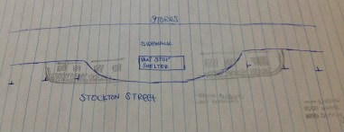
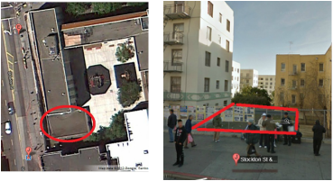
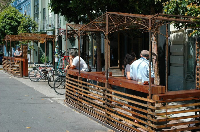
On the first floor of the mall, new lighting and seating can be installed to make the area more inviting for people to visit and thus would benefit the retail stores there. The entrance of the mall should also be aesthetically improved upon to make the mall more welcoming. -O.G. Stockton Street’s Scarce Transportation infrastructure As well everyone knows, Stockton Street is an incredibly congested street filled with pedestrians, cars, trucks, and buses. As these different users of the street make their trips from point A to point B on Stockton Street, they are thrust into a competition to claim Stockton Street’s scarce transportation infrastructure - two lanes of traffic, two lanes of street parking, and narrow sidewalks about 9 feet wide. Close research into the spatial dynamics of each transit mode’s needs is required to improve transportation effectiveness along this corridor. Where Competition Intensifies Where this competition is most intensified is in the space between the sidewalk and the main thoroughfare. This space is most commonly used as street parking, but a simple stroll through Stockton Street shows that the space is also used for bus stop bulb-outs (and other sidewalk extensions), commercial loading/unloading zones, and even, as is very common between Jackson and Broadway, pedestrian traffic spillover. Where we want to focus our efforts is on the “street parking, sidewalk extension, loading/unloading, pedestrian spillover” zone for several reasons. The first reason is that this is the space with the most flexibility and opportunity for physical modification. Modifying this space is much more physically viable than actually widening the street itself. The second reason is that this space is also the space that is most abused. Commercial trucks stay parked long after their parking meters have expired. Street vendors sell their produce illegally near bus bulb-outs, and even the established businesses extend their product display and storage space into the street. And pedestrians, in an effort to move efficiently and quickly through the crowded sidewalk, often place themselves in danger by moving off the sidewalk and into this space near the main thoroughfare. An opportunity for open space Modifying this 7-9 foot wide space in the transit thoroughfare is not only a transportation project. Recent trends in the redesign of the space, such as in the use of “parklets”# (approved of and promoted by the city government), are breathing new ideas into where public and open space can be used. Currently, most of these parklets are designed for leisurely, passive activities such as sitting, eating snacks, and conversing. “Open space,” as demonstrated by these parklets, is a very flexible concept. This idea easily lends itself to open space provision in this narrow space, especially through the relevant example of Parking Day, a day in which people legally reserve parking spaces to create small parks.# Since Chinatown is one of the most underserved communities with regards to open space provision,# there is a tremendous opportunity presented here to create more open spaces while making physical modifications of Stockton Street for transit purposes. This is not an entirely new idea to Chinatown; the Chinatown Alleyway Master Plan, among its many objectives, creates a hybrid of 1) flexible open space for passive recreation and 2) transit effectiveness projects, specifically through creating a secondary pedestrian network. Our Proposal What we propose is to create hybrid parklets which not only serve as “open space” but also as transit effectiveness projects. As we conduct field research into the spatial dynamics of each transit mode’s need long this corridor, we expect to find opportunities to implement parklets which can be tailored to each of those situations. At this point, we want to create a “design toolkit of parklets” which can be easily implemented various Chinatown nonprofits and associations. We hope that the success of these parklets will eventually cause the city to assist Chinatown nonprofits in these innovative efforts and perhaps, where necessary, construct permanent sidewalk extensions. There are several hybrid parklet design templates which we have already created: - Pedestrian expressway: For Stockton Street in between Jackson and Broadway, where it the most crowded due to the high number of businesses selling produce and prepared food. The main purpose of these expressways is to safely channel the pedestrian spillover occurring on these blocks. The fact that there is pedestrian spillover demonstrates that there is not enough space on the sidewalk and that the space that is normally reserved for parking is underutilized and should therefore be prioritized to meet pedestrian needs. The expressways would relieve congestion on the sidewalk also through creating two distinct spaces along those shopping corridors - one space, on the sidewalk, for shopping, and the other space, in the expressway, to get from point A to point B. - Leisure activity: For the calmer areas of Stockton Street, where pedestrian traffic is still moderate along the sidewalk, and where people would like for an area to meet in public. Bus stop expansion: For various bus stops on Stockton which are heavily-used. The purpose of this parklet is to provide seating and improve efficiency and ensure safety of the onboarding/offboarding process. Tradeoffs We recognize is that these parklets will have two effects: one, remove the number of street parking available on Stockton Street, and two, remove loading/unloading zones. We feel that these tradeoffs are worth making for several reasons. First, because Stockton Street is already so congested, most local drivers have the tendency to avoid Stockton Street (will research to see if this is true; just our hypothesis). In the most crowded of areas, there is really no need for parking, and parking is often abused by commercial trucks who overstay their metered time. Secondly, commercial trucks not only abuse parking spots but also loading/unloading zones. By limiting the space in which they can load and unload their goods, we not only ensure that these spaces remain transient spaces and force business to collaborate loading and unloading times to create a more efficient system. The number of parklets to be implemented is still undecided. The advantage of having these parklets is that that they are essentially tests and experiments to see what will work and won’t work. Because parklets are quite flexible, they can be easily set up and taken down, and with local nonprofits and associations facilitating this process, there is a high chance that this process will be highly responsive to community Other related long-term goals
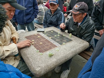
Besides parklets, we also propose other types of open space along Stockton Street that might take a longer time to accomplish. An example of this open space would be opening a community center on top of the Ping Yuen housing project located on Pacific Avenue and Stockton Street. Open community space is very limited in Chinatown due to it’s zoning laws. Because of this, we must find very creative ways to provide open space to accommodate the needs of the Chinatown community. The proposed Ping Yuen community center will provide a place for Chinatown residents to relax and also will serve as a meeting place for the Chinatown community. Another way we propose to create more open space on Stockton Street is to utilize the new Central Subway Station. We propose to open a new park or recreation center on the roof of the new Central Subway Station. This park or recreation center will provide a much needed space for Chinatown youths to stay off the streets. This week, we got to see many different types of open space, whether publicly owned or privately owned. One thing is for sure, open space is highly needed in such a congested Chinatown. With Kearny Street as our corridor, we have the privately owned public open space, Empire Park just located in Commercial Alleyway between Kearny St. and Montgomery St and then there is Portsmouth Square, one of the four Playgrounds in Chinatown. After several observations, we discovered that Portsmouth Square has potential to improve for quality open space. 1) Many users of Portsmouth Square come to this space to gather and socialize, to exercise, to catch the sun, and so much more. Therefore, we find it crucial to have more seating. Our proposal is to replace the overgrowing bushes and trees that surround Portsmouth Square on the side of Kearny St. with possible amphitheater-like seating stage with greenery added in between these steps. This way it will increase seating as well as space for people to walk around and exercise on. Possible seating blocks are also a way to increase seating space. 2)Another proposal would be implementing Chinese Checkers/Chess stations onto stone blocks. Many grandpas use this open space every day to play Chinese chess. Although there’re already stone blocks set on the lower portion of Portsmouth Square, the design is not really set for the game. Why not have actual Chess/Checker seating made out than for them to draw it on their own. 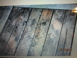 As for the corridor along Kearny and Jackson, we’d like to propose for a possible parklet in front of City College of San Francisco. With I-Hotel, St. Mary’s primary School, and a CCSF on the same block, we find it crucial to have
Transit Ridership - Observations From our observations, we saw that the 30 line was very crowded, especially in the Chinatown neighborhood (down Stockton, in between Columbus and Sacramento). In fact, at one point during the field observation, we saw buses so crowded that the bus rider had to ask some passengers to leave to be able to safely close the doors and drive the bus down Stockton St. Most of the ridership was Chinese, and it seemed like the children and elderly made up the majority of the riders. The rest of the ridership was quite diverse, ranging in age, ethnicity, and gender, and that fact wasn’t entirely lost in the slightly more homogeneous crowd of Chinese riders. Transit Ridership - TEP Data According to passenger data collected by the Transit Effectiveness Project, the 30 Stockton line accommodates 10,000 to 12,000 passengers per day. The stops in Chinatown are the busiest and accommodate for around 6,000 passengers per day. The Stockton and Washington intersection, for example, accommodates a daily load of 6,313 passengers. The only stops which come close to these numbers are those stops around Market Street, a major transit thoroughfare. The 9BX Route (now the 8 route) used to pass through Stockton and Chinatown. Those stops in Chinatown on Stockton Street (Stockton St & Columbus Ave, Pacfic, Ave, Washington St, and Sacramento St), accommodate a daily load of around 1,000 passengers (952; 1,145; 1,270; 1,325 passengers, respectively). The 9X (also part of the 8 route) added to this load with around 4,000 passengers daily (peaking at around 5,006 passengers on Stockton St & Sacramento St). However, now the 8 route does NOT pass through Chinatown, which begs the question - where do all these riders now go? The 45 Route bus accommodates around 4,000 passengers as it passes through Chinatown on Stocktown, with the peak stop also being Stockton St & Sacramento St with 3,580 passengers total. This data from the TEP was taken, most recently, in the fall of 2007, and so may be outdated and slightly unreflective of transit ridership. If anything, transit ridership may have increased in these areas since gas prices have risen since that year and because of the recent economic recession. With these numbers, we can safely conclude that Stockton street is a major thoroughfare for bus riders despite its congestion and narrow streets. Many riders in fact do use the bus, which makes it an important target for transit improvement. It was actually quite difficult to find demographic ridership data on transit ridership. When asked, Felipe, a transit planner at SFMTA working on TEP, mentioned that most transit ridership data is based on census data. It is assumed that ridership demographics reflect the demographics of the districts which public transit passes through. It seemed that this was the method they chose to use due to the problematic task of taking transit ridership data in the field - surveys would be too slow and invasive, yet untrustworthy assumptions would have to be made if researchers simply guessed a rider’s ethnicity, age, or even gender. Transit Service Type, Bus Stops, and Rider Amenities
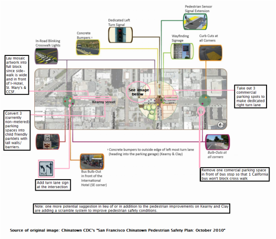
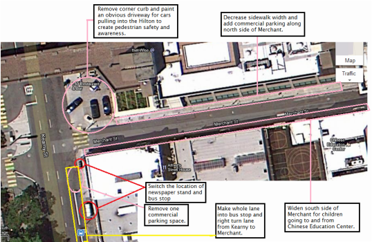
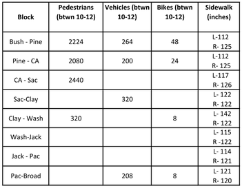
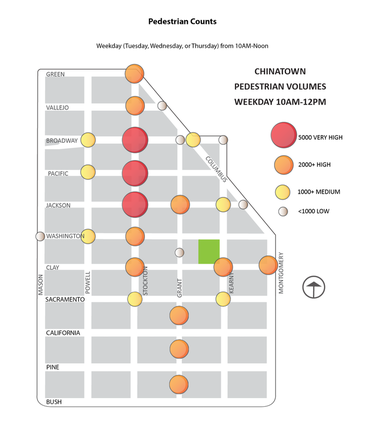
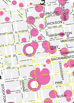
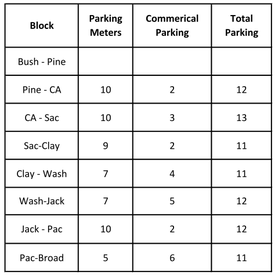
In terms of types of transit services, there are many busses with different routes which transport customers to all areas around the city. Busses travel to the north, east, south, and to the west corridors of Chinatown, which gives the convenience of transportation to its residents. Bus routes includes, but are not limited to the 1-Downtown(Inbound)/ Richmond District (Outbound), 30- Caltrain (Inbound)/ Marina District (Outbound), and 8X-Fisherman’s Wharf (Inbound)/ City College (Outbound). Bus stops in Chinatown, especially in the busier blocks, become overpacked with residents waiting for the bus. This becomes an obstacle for pedestrians who are walking along the regular streets. On streets such as Stockton and Broadway, bus stops have been extended into a bulb-out. These bulb-outs allows for more pedestrian flow along the streets, while allowing sufficient waiting space for bus riders. Some bus stops shelters along Stockton street have been redesigned with black plastic seats, an electronic advertisement screen, as well as a red wave-like roof. Muni transit offers rider amenities such as wheelchair accessibility, elderly and disabled priority seating, and the clipper program. Recommendations for Improvement Sidewalk extensions for bus stops: With such narrow road space on Stockton Street, the MUNI buses face difficulties pulling in and out of travel lanes to pick up riders. Transit bulbs will allow buses to pick up riders without having to pull out of their traffic lane and then wait for a space to merge back in. Lines at bus stops and passenger/driver education: Certain bus stops in Stockton can be chaotic because a large amount of riders are struggling to enter the bus. Waiting time increases at each bus stop when entering riders do not wait for people to exit first. If riders are lined up orderly to enter the bus, the buses can leave each bus stop faster. Some sort of ridership etiquette education campaign would provide an outreaching avenue which could make the onboarding, offboarding, and ridership experience more efficient and pleasant for all users. Since many riders on Stockton are monolingual, there is a language barrier between the driver and riders. Prerecorded announcements in Cantonese can help drivers communicate better with passengers. Widening traffic lanes During our bus tour, Felipe noted that from Columbus Avenue to Broadway, MUNI buses barely fit on their traffic lane. The lane is so narrow that the bus wheel touches the yellow lane line. Large vehicles that pass by in the opposite directions must yield for the MUNI bus. The protruding side mirrors of MUNI buses is an additional hazard for cars that are passing by in narrow lanes. The driving lane can be increased by reducing parking or decreasing sidewalk space. Team Kearny’s goals for our assessment and recommendations for the Kearny St. corridor align with the goals of CCDC’s Chinatown Pedestrian Safety Plan. We hope to find a balance between the corridors high volume of vehicles with the many pedestrians and community-oriented uses in the area. Our ideas for improvement hope to achieve the following: -Increase pedestrian safety -Reducing speed of vehicular traffic -Increasing effective flow of vehicular traffic off and onto Kearny This assessment and recommendations will walk the reader north on Kearny, starting at Sacramento and ending at Columbus, hitting on the key issues that arise. Kearny and Clay The bus 8X (towards North Point and Kearny) is serving mostly residents around San Francisco. According to SFMTA’sTransit Effectiveness Project (TEP) data, most passengers get off at these following stops: Kearny and Clay, Kearny and Jackson, Kearny and Columbus in the morning. Its daily load of passengers on the bus stop at Kearny and Clay is 2,569. Kearny & Clay also tied for 4th place for the most dangerous intersection, according to survey participants of CCDC’s Chinatown Pedestrian Needs Assessment. According to the same study, there were around 2-5 vehicle/pedestrian injury collision between Sacramento and Kearny, 6-10 injuries between Clay and Kearny, and 2-5 between Washington and Kearny. This intersection consistently has high volumes of pedestrians (over 2000 per two hours) at peak use times (weekday 10AM-12PM and 3PM-5PM and weekend 10AM-12PM). Because of the high volume of MUNI riders and pedestrians at this intersection, we recommend removing 3 commerical parking spots so that two buses can fit in the bus stop. Currently, the tail end of the 8X bus often protrudes into the crosswalk, making crossing west (going uphill) towards the heart of Chinatown very dangerous. Also, in addition to or in lieu of CCDC’s pedestrian safety recommendations for the intersection, we suggest a scramble system for the cross walk in order to create more safety for pedestrians and transit users of the 1 and 8x bus lines. Kearny and Merchant Walking down Kearny Street, we find the most problems on Kearny Merchant, an alleyway next to Hilton where there is a 8X stop, many commercial and private cars turning into the alleyway, and taxis and cars turning into the Hilton’s drop off zone. Merchant alleyway has a whole host of problems, including narrow south side sidewalk that is heavily used by children from the Chinese Education Center, illegally parked commerical vehicles on the south side sidewalk which has “No Parking” signs, an underutilized north side sidewalk that is adjacent to the Hilton and dangerous right turn conditions for cars coming off Kearny onto Merchant. For the safety of pedestrians, we recommend removing the lone commercial parking spot on Kearny between Clay and Merchant, which is north of the bus stop and before Merchant. We have noticed that the bus often does not pull into the bus stop and sits in traffic while passengers unload or other commercial vehicles illegally park in the bus stop if the one commerical parking spot is taken. During our field study, we saw a commercial dishwashing vehicle (on the assumption that it was servicing the Hilton and not the nearby Chinese restaurants) idle at the bus stop while eating lunch; the air pollution and unsafe unloading conditions for the bus were dangerous to transit users. To compensate for the lost parking spot, we recommend decreasing the width of the north side of Merchant, adding commercial parking all along the north side, and widening the south side of Merchant for pedestrian and children safety. Kearny and Jackson According to CCDC’s Chinatown Pedestrian Safety Needs Assessment, this intersection tied as the intersection found most dangerous by residents of CCDC-owned properties. This intersection is the northernmost corner of the newly developed block with the International Hotel (a residential hotel for Asian elderly folks), St. Mary’s school (a private K-8 school), and City College of San Francisco Chinatown campus. Like all the other bus stops on Kearny, all the 8 lines stop at this bus stop (8 shuttle, 8X, 8AX, and 8BX), all of which with the exception of the 8 bring people from southeast neighborhoods like Bayview, Portola and Visitacion Valley to Chinatown. During peak use times, Kearny and Jackson has pedestrian volumes of over 1000 people per two hours, according to the Chinatown Pedestrian Safety Plan. According to Team Kearny’s own data collection at Kearny and Washington (the southeast corner of the newly redeveloped block) from 10:40-11AM, we counted 192 cars per twenty minutes, 4 charter buses, and 1 MUNI bus, which is 576 cars per hour, 12 charter buses per hour, and 3 MUNI buses per hour. We chose this intersection because vehicles passing this intersection would rumble past the block with CCSF, St. Mary’s and I-Hotel. We made recommendations to improve the block that serves youth, elderly, and students, such as adding parklets in 3 (currently nonmetered) parking spaces in front of CCSF, with the hope that they will be children friendly and sponsored/maintained by St. Mary’s. In-laid mosaic artwork on the wide sidewalks also would liven up the newly repaved street. Lastly, we agree with CCDC’s recommendations to create a bulb out at the bus stop in front of I-Hotel. Note on Bicycling on Kearny According to the Pedestrian Safety Plan, the following Kearny intersections were ranked respectively relative to other Chinatown intersections in volume of bicyclists: Kearny & Sacramento (ranked 8), Kearny & Clay (ranked 7), and Kearny & Jackson (ranked 10) on weekdays from 10AM-12PM. During the weekend, volumes drop, indicating that most bicyclists going down Kearny are morning work commuters. Though the volume of bicyclists on Kearny doesn’t justify adding a bicycle lane at the expense of transit and car volumes, we do recommend adding wayfinding bike symbols along the eastern (right) lanes or right turn lanes so that bicyclists have some guidance as to where to ride such that they won’t get doored by parked cars or trucks. Sources: SF MTA’s Transit Effectiveness Plan (TEP) http://www.sfmta.com/cms/rtep/tepdataindx.htm San Francisco Chinatown Pedestrian Safety Plan http://sf.streetsblog.org/wp-content/upload1/ChinatownPedestrianSafetyPlan_Final.pdf San Francisco Chinatown Pedestrian Safety Needs Assessment http://sf.streetsblog.org/wp-content/upload1/ChinatownPedestrianNeedsAssessment_Final.pdf The two images below depict Team's Kearny's recommendations for transit improvements for Kearny between Sacramento and Columbus. Grant Avenue is a moderately wide corridor with enough width to park three cars from curb to curb. Grant has a one-way lane, but towards the end of most blocks, one lane splits into two, adding a right turn lane. Also Grant only has a left lane for parking. Modes of Transportation We conducted pedestrian, vehicle, and/or bike counts on Grant Ave entrance, on Grant between Pine and California, and on Grant between California & Sacramento. Method Two persons stood parallel in the middle of a block on the left and right sidewalks and we used manual counters. We counted people who walked by us in any directions for fifteen minutes. For example, from 10:00 - 10:15 am and 10:20 - 10:35 pm. We then multiplied this number by eight to bring us to total counts per 2 hours to correspond to the CCDC Chinatown Pedestrian Needs Assessment - Pedestrian Count. We incorporated our data into the report, which only had Jackson and Broadway counts along Grant. Result Our numbers indicated heavy foot traffic at the Chinatown entrance gates by mostly tourists at 2,224 individuals per 2 hours. A decline in pedestrians on Grant occurred between Pine and California with 2,080 and a small increase occurred between California and Sacramento with 2,440 individuals per hour. Using this data we can gather that the center streets of Chinatown on Grant street are heavily used by wandering tourists and residents that purchase goods from the commercial businesses on Grant street. We found that bike users entered through the Chinatown gates at 48 bikes per 2 hours. The bicyclists tend to be tourists, whereas toward the center and end of Grant, there were a few locals on bikes. Our vehicle count revealed that the beginning and end of the Grant corridor had the fewer traffic than the center of Grant - Sacramento & Clay which had 40 vehicles/ 15 min or 320/ two hours. Even though there is low traffic on Grant Ave, cars move along slowly because of cars parking and making turns. Besides cars and vans, delivery trucks are pretty common. Our fieldwork indicated to us that foot traffic is the most commonly utilized mode of transportation. Between each street, we measured sidewalk length on both sides using measuring tape. Our findings are indicated below. We observed that a majority of the businesses will take up sidewalk space by placing their goods in front of their business. Some extensions protrude up to 55 km causing congestion as pedestrians linger the storefronts to eye the goods and take up half of the sidewalk. Parking There are no MUNI lines run along Grant Ave, so we decided to focused on vehicle parking by looking at the space and meters. Method We recorded the number of commercial and regular meters and then observed the surroundings of parking spaces. Map from SFPark Yellow - Commercial Loading Gray - General Metered Green - Short Term Results It is definitely difficult to find a spot when there are only a total of 82 parking meters between Pine & Broadway, but general parking does not appear to be an major issue with the existing to three parking garages nearby. As we go down the corridor there are fewer general parking and more commercial parking. We observed that the parking spaces benefit businesses in that most are commercial unloading and passenger drop-off zones. Each block has varied sections of commercial parking and usually correlates with a business front. Proposals
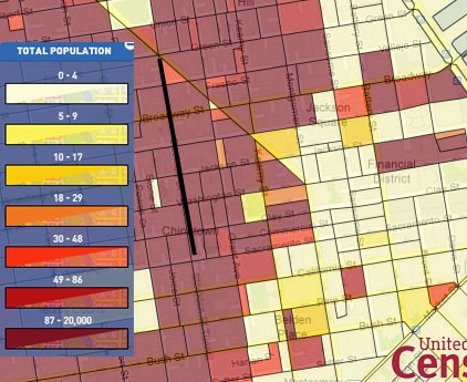
Overall, Grant Ave is very efficient in terms of transit as a corridor. Our field study shows that rarely is there any vehicle traffic during the morning and the huge flow of people is well accommodated by the two lanes of sidewalks. Many drivers, knowing that Grant Ave. is a street where people commonly J-walk, proceed slowly and cautiously and occasionally also stop not at an intersection to allow pedestrians to j-walk across. To promote safety, a few signs should be placed visibly throughout Grant Ave. to warn drivers to slow down or in other words, to anticipate people who might suddenly pop out J-walking. With the slow car traffic, many bikers are able to safely maneuver in and out of Grant Ave as well. Another measure that we would propose is to have road and intersection markings repainted for transit safety. We notice that many of the current markings are faded away. The color-coded curb markings, designating which type of parking is allowed, should also be repainted for visibility. The right lane of Grant prohibits parking or stopping. However, occasionally delivery trucks park drive onto the sidewalk, when there is no parking available. This is usually due to cars occupying parking space that is designated for unloading vehicles. Drivers either park half or the nearly the entire vehicle onto the sidewalk. This is especially dangerous when there are many pedestrians. Most of the Chinatown population are seniors and children, and drivers may not see pedestrians. Another concern is that there is less space for people to walk. Some businesses already take up part of the sidewalk with merchandise. When trucks park in front of a store, pedestrians need to squeeze through. Our solution then is to enforce where vehicles can and cannot park by increasing ticketing and to encourage people to report illegal parking. The idea is to ensure that cars do not park where the parking space is designated for loading trucks. This would deter loading trucks from parking onto the sidewalk and taking up sidewalk space that is already very limited and heavily used by pedestrians. Sidewalk space is heavily utilized in Grant Ave by both tourists and locals and occasionally by bikers. Often, commercial and retail stores would take up a lot of sidewalk space by placing their merchandises outside of their storefronts. To increase the availability of sidewalk space so that pedestrians don’t have to walk out of the sidewalk and into the road to get by, we would like to recommend higher enforcement of merchandise placement on sidewalk space. -O.G. Housing StockResearch Method In order to take an accurate count of the housing stock on Stockton St between Columbus and Sacramento, we decided to try to count the housing stock in person, on the field. We split into two groups, and each group counted the housing of either the western or the eastern blocks. Our main approach was to count mailboxes of each residential unit. For some residential units, we had to enter into the building to count mailboxes, or we had to enter into the floors and count the number of SRO units on that floor and multiply it by the number of residential floors in that building. In other cases, brief interviews were conducted with managers and landlords with very little patience who demanded documentation from us after we explained to them our study and our connection the the Chinatown Urban Institute. Regarding those buildings (about 11 buildings) for which we were unable to do any of these methods, we have added to ours list 1 unit of housing, and so our numbers, as estimates, are probably lower than what the actual housing stock is. Data Total # of housing units: 963 (majority SROs) # of housing units on western side: about 521 # of housing units on eastern side: about 442 History & Age According to the Social Explorer, the houses on the blocks to the right and left of Stockton between Columbus and Sacramento were, on average, built before 1940. Most buildings were built immediately after the San Francisco 1906 earthquake and have undergone little significant remodeling since then. Residents SnapshotResearch Method Stockton is a popular and very busy commercial street. According to a Department of Public Works press release, a study by the SFMTA estimated the corridor sees about 2,000 pedestrians per hour — and that’s on an average day. Therefore, the people on the streets may not be representative of the immediate local residents. Thus, we thought it would be more effective to find information about Stockton St's residents through online research. Stockton Street Stockton is extremely dense. According to the 2010 Census (see graphic below), the number of people living in the blocks to the right and left of Stockton between Columbus and Sacramento range from 186-600 persons per block. Comparability to Chinatown as a Whole
The density of Stockton St is reflective of Chinatown's overall density. 20,000 residents live in Chinatown's 30 square blocks. These residents also most likely reflect the characteristics of Chinatown's population as a whole, since the housing stock consists mostly of SROs, which are usually inhabited by long term, low-income, senior residents who rent housing. In the greater context of Chinatown, the average median annual income of the residents is about $18,000, and more than a third of the population consist of seniors living on fixed incomes. 88% of Chinatown residents are renters. We imagine that this description matches the characteristics of those living on Stockton St between Columbus and Sacramento. |



 RSS Feed
