|
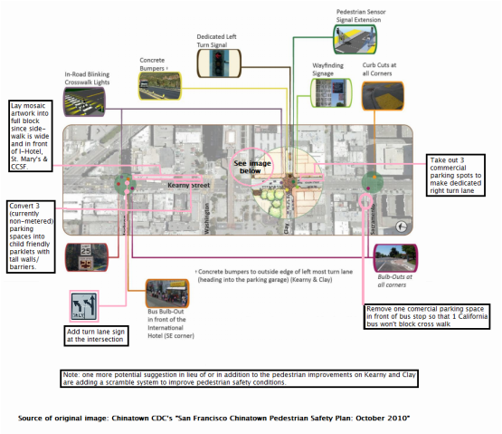
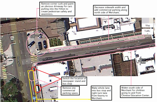
Team Kearny’s goals for our assessment and recommendations for the Kearny St. corridor align with the goals of CCDC’s Chinatown Pedestrian Safety Plan. We hope to find a balance between the corridors high volume of vehicles with the many pedestrians and community-oriented uses in the area. Our ideas for improvement hope to achieve the following: -Increase pedestrian safety -Reducing speed of vehicular traffic -Increasing effective flow of vehicular traffic off and onto Kearny This assessment and recommendations will walk the reader north on Kearny, starting at Sacramento and ending at Columbus, hitting on the key issues that arise. Kearny and Clay The bus 8X (towards North Point and Kearny) is serving mostly residents around San Francisco. According to SFMTA’sTransit Effectiveness Project (TEP) data, most passengers get off at these following stops: Kearny and Clay, Kearny and Jackson, Kearny and Columbus in the morning. Its daily load of passengers on the bus stop at Kearny and Clay is 2,569. Kearny & Clay also tied for 4th place for the most dangerous intersection, according to survey participants of CCDC’s Chinatown Pedestrian Needs Assessment. According to the same study, there were around 2-5 vehicle/pedestrian injury collision between Sacramento and Kearny, 6-10 injuries between Clay and Kearny, and 2-5 between Washington and Kearny. This intersection consistently has high volumes of pedestrians (over 2000 per two hours) at peak use times (weekday 10AM-12PM and 3PM-5PM and weekend 10AM-12PM). Because of the high volume of MUNI riders and pedestrians at this intersection, we recommend removing 3 commerical parking spots so that two buses can fit in the bus stop. Currently, the tail end of the 8X bus often protrudes into the crosswalk, making crossing west (going uphill) towards the heart of Chinatown very dangerous. Also, in addition to or in lieu of CCDC’s pedestrian safety recommendations for the intersection, we suggest a scramble system for the cross walk in order to create more safety for pedestrians and transit users of the 1 and 8x bus lines. Kearny and Merchant Walking down Kearny Street, we find the most problems on Kearny Merchant, an alleyway next to Hilton where there is a 8X stop, many commercial and private cars turning into the alleyway, and taxis and cars turning into the Hilton’s drop off zone. Merchant alleyway has a whole host of problems, including narrow south side sidewalk that is heavily used by children from the Chinese Education Center, illegally parked commerical vehicles on the south side sidewalk which has “No Parking” signs, an underutilized north side sidewalk that is adjacent to the Hilton and dangerous right turn conditions for cars coming off Kearny onto Merchant. For the safety of pedestrians, we recommend removing the lone commercial parking spot on Kearny between Clay and Merchant, which is north of the bus stop and before Merchant. We have noticed that the bus often does not pull into the bus stop and sits in traffic while passengers unload or other commercial vehicles illegally park in the bus stop if the one commerical parking spot is taken. During our field study, we saw a commercial dishwashing vehicle (on the assumption that it was servicing the Hilton and not the nearby Chinese restaurants) idle at the bus stop while eating lunch; the air pollution and unsafe unloading conditions for the bus were dangerous to transit users. To compensate for the lost parking spot, we recommend decreasing the width of the north side of Merchant, adding commercial parking all along the north side, and widening the south side of Merchant for pedestrian and children safety. Kearny and Jackson According to CCDC’s Chinatown Pedestrian Safety Needs Assessment, this intersection tied as the intersection found most dangerous by residents of CCDC-owned properties. This intersection is the northernmost corner of the newly developed block with the International Hotel (a residential hotel for Asian elderly folks), St. Mary’s school (a private K-8 school), and City College of San Francisco Chinatown campus. Like all the other bus stops on Kearny, all the 8 lines stop at this bus stop (8 shuttle, 8X, 8AX, and 8BX), all of which with the exception of the 8 bring people from southeast neighborhoods like Bayview, Portola and Visitacion Valley to Chinatown. During peak use times, Kearny and Jackson has pedestrian volumes of over 1000 people per two hours, according to the Chinatown Pedestrian Safety Plan. According to Team Kearny’s own data collection at Kearny and Washington (the southeast corner of the newly redeveloped block) from 10:40-11AM, we counted 192 cars per twenty minutes, 4 charter buses, and 1 MUNI bus, which is 576 cars per hour, 12 charter buses per hour, and 3 MUNI buses per hour. We chose this intersection because vehicles passing this intersection would rumble past the block with CCSF, St. Mary’s and I-Hotel. We made recommendations to improve the block that serves youth, elderly, and students, such as adding parklets in 3 (currently nonmetered) parking spaces in front of CCSF, with the hope that they will be children friendly and sponsored/maintained by St. Mary’s. In-laid mosaic artwork on the wide sidewalks also would liven up the newly repaved street. Lastly, we agree with CCDC’s recommendations to create a bulb out at the bus stop in front of I-Hotel. Note on Bicycling on Kearny According to the Pedestrian Safety Plan, the following Kearny intersections were ranked respectively relative to other Chinatown intersections in volume of bicyclists: Kearny & Sacramento (ranked 8), Kearny & Clay (ranked 7), and Kearny & Jackson (ranked 10) on weekdays from 10AM-12PM. During the weekend, volumes drop, indicating that most bicyclists going down Kearny are morning work commuters. Though the volume of bicyclists on Kearny doesn’t justify adding a bicycle lane at the expense of transit and car volumes, we do recommend adding wayfinding bike symbols along the eastern (right) lanes or right turn lanes so that bicyclists have some guidance as to where to ride such that they won’t get doored by parked cars or trucks. Sources: SF MTA’s Transit Effectiveness Plan (TEP) http://www.sfmta.com/cms/rtep/tepdataindx.htm San Francisco Chinatown Pedestrian Safety Plan http://sf.streetsblog.org/wp-content/upload1/ChinatownPedestrianSafetyPlan_Final.pdf San Francisco Chinatown Pedestrian Safety Needs Assessment http://sf.streetsblog.org/wp-content/upload1/ChinatownPedestrianNeedsAssessment_Final.pdf The two images below depict Team's Kearny's recommendations for transit improvements for Kearny between Sacramento and Columbus.
0 Comments
Leave a Reply. |


 RSS Feed
